


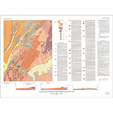
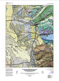

Geologic Map of the Rush Valley 30' x 60' Quadrangle, Tooele, Utah, and Salt Lake Counties, Utah (M-294DM)
By: Donald L. Clark, Stefan M. Kirby, and Charles G. Oviatt
The quadrangle extends southwest and west from the heavily populated greater Salt Lake City–Provo metropolitan area in the eastern Basin and Range Province, and includes several mainly north-south-trending mountain ranges and intervening valleys. Bedrock geologic units from Neoproterozoic to Miocene age are overlain by Neogene and Quaternary surficial deposits. Geologic structure is related to the Uinta-Tooele structural zone, Sevier orogenic belt, and Basin and Range extension. Surficial deposits are largely related to latest Pleistocene Lake Bonneville and alluvial depositional environments. This map shows the geology of the quadrangle at an intermediate scale (1:62,500). The accompanying map explanation includes an introductory text, geologic unit descriptions, figures, tables, photos, mapping sources, geologic units, correlation charts, geologic symbols, lithologic columns, and geologic cross sections. GIS data are included.
Other Information
Published: 2023
Pages: 46
Plates: 3
Scale: 1:62,500
Location: Utah
Media Type: Paper Map & Report