


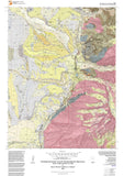


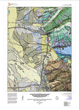
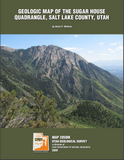
Geologic map of the Sugar House quadrangle, Salt Lake County, Utah (M-285)
by Adam P. McKean
The Sugar House 7.5-minute quadrangle is located within Salt Lake County on the eastern margin of Salt Lake Valley and includes the mountain front of the Wasatch Range. A number of creeks flow from the Wasatch Range into the valley, including Red Butte, Emigration, Parleys, Mill, Big and Little Cottonwood Creeks, and smaller creeks. The urbanized valley floor part of the quadrangle includes Salt Lake City in the northern part; Holladay, Millcreek Township, and South Salt Lake City in the central part; Murray, Midvale, and Cottonwood Heights in the southern part; and areas of unincorporated Salt Lake County. In the Wasatch Range the quadrangle contains part of the Mount Olympus Wilderness area and recreation areas in Mill Creek and Neffs Canyons, and other parts of the UintaWasatch-Cache National Forest. The Sugar House quadrangle was mapped partly to provide the basis for identifying and delimiting potential geologic hazards for derivative Utah Geological Survey (UGS) geologic hazard maps of urban and rapidly developing areas being prepared by the UGS Geologic Hazards Mapping Initiative.
Other Information:
Published: 2020
Pages: 35 p.
Plates: 2 pl.
Scale: 1:24,000
Location: Salt Lake County
Media Type: Paper Map