


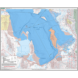
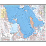
Bathymetric Great Salt Lake South
The U.S. Geological Survey collected bathymetric data for the north part of Great Salt Lake during the spring and early summer of 2006 using a single-beam, high-definition fathometer and real-time differential global positioning system. About 5.2 million depth measurements were collected along more than 765 miles of survey transects. Area and volume calculations show a maximum area of about 385,000 acres and a maximum volume of about 5,693,000 acre-feet at a water-surface altitude of 4,200 feet. Minimum natural water-surface altitude of the north part of Great Salt Lake is just below 4,167 feet in the area just north of the Union Pacific railroad causeway halfway between Saline and the western edge of the lake. This map concentrates on the data taken for the southern part of the Great Salt Lake.
Other Information:
Dimensions: 36" x 30"
Location: Utah
Type: Paper Map