


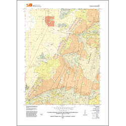

Interim geologic map of the Ephraim 7.5-minute quadrangle, Sanpete County, Utah (OFR-556)
By: H. H. Doelling, P. A. Kuehne, G. N. McDonald, and D. J. Lidke
The Ephraim quadrangle is located about 140 miles south-southeast of Salt Lake City in Sanpete County in central Utah. A diagonal line, extending NE-SW across the quadrangle, divides Sanpete Valley to the northwest, from the Wasatch Plateau. Sanpete Valley is a structural feature in which the San Pitch River flows south along its west margin. Quaternary fans form a gently sloping surface from the plateau front to the floodplain of the river.
Bedrock units are mostly of early Tertiary age. These include the North Horn Formation, Flagstaff Limestone, Colton Formation, Green River Formation, and the Crazy Hollow Formation. Of these, the North Horn Formation may also have some Late Cretaceous strata at the base. The older three units are exposed in the Wasatch Plateau, the other two along the plateau-valley margin.
Other Information:
Published: 2009
Pages: 35 p.
Plates: 1 pl.
Scale: 1:24,000
Location: Sanpete County
Media Type: Paper Map