


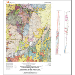
Provisional geologic map of the Tintic Mountain quadrangle, Juab and Utah Counties, Utah (OFR-545)
By: J. D. Keith, D. G. Tingey, J. L. Hannah, S. T. Nelson, D. K. Moore, T. M. Cannan, and A. P. MacBeth
The Tintic Mountain quadrangle is located in central Utah about 6 miles south of Eureka near the central part of the East Tintic Mountains. The quadrangle is on the east margin of the Basin and Range Physiographic Province. Because the quadrangle is partly within the East Tintic mining district, numerous geologic studies have been done on the area. Morris and Lovering prepared the most comprehensive report on the district; other examples are listed in the references in this open-file report. U.S. Geological Survey geologist H.T. Morris previously mapped the geology of the Tintic Mountain quadrangle. Subsequent mapping occurred in the west and northeast parts of the quadrangle. This map focuses on the Tertiary volcanic rocks, and relies on geochemical, geochronologic, and stratigraphic data from Moore?s M.S. thesis supervised by J.D. Keith. The stratigraphy of the Tintic Mountain Volcanic Group has been revised from that of Morris and Lovering with a mix of formal and informal rock unit names. The quadrangle was remapped in an effort to update and build upon the prior mapping and geologic studies of H.T. Morris.
Other Information:
Published: 2009
Pages: 15 p.
Plates: 1 pl.
Scale: 1:24,000
Location: Juab County and Utah County
Media Type: Paper Map