


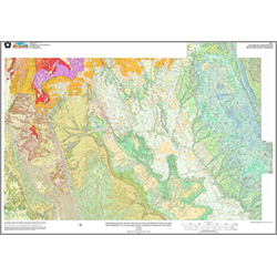
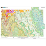
Interim geologic map of the Escalante and parts of the Loa and Hite Crossing 30' x 60' quadrangles, Garfield and Kane Counties, Utah (OFR-368)
OFR368
Unstocked
1:100,000 Geologic Maps
$14.95
By: H. H. Doelling and G. C. Willis
This publication is a geologic map of the Escalante and parts of the Loa and Hite Crossing 30' x 60' quadrangles. The text in the publication contains information containing description of map units, correlation of bedrock units, correlation of surficial deposits, thickness ranges of geologic units, a lithologic column, and a cross section. This open-file release makes information available to the public which may not conform to UGS policy, editorial, or technical standards. Therefore it may be premature for an individual or group to take actions based on its contents.
Other Information:
Published: 1999
Pages: 26 p.
Plates: 1 pl.
Scale: 1:100,000
Location: Garfield County and Kane County
Media Type: Paper Map