


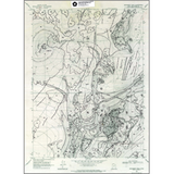
Interim geologic map of the Monument Peak quadrangle, Box Elder County, Utah and Oneida County, Idaho (OFR-344)
By: D. M. Miller and H. Langrock
This group of maps (OFR-444 to OFR-349 includes much of the broad, gently south-sloping eastern Curlew Valley as well as parts of the Wildcat Hills, southern Hansel and southern Sublett Range, southwestern Hansel Valley, and the northwestern part of Great Salt Lake and its mud flats. Part of Sage Valley, a small internally drained valley west of the Hansel Mountains, also is present.
Information in this publication includes: text of the geology history of the quadrangle, description of map units, and correlation of map units. This Open-File release makes information available to the public during the review and production period necessary for a formal UGS publication. This map may be incomplete, and inconsistencies, errors, and omissions have not been resolved. While the document is in the review process, it may not conform to UGS standards; therefore it may be premature for an individual or group to take actions based on its contents.
Other Information:
Published: 1997
Pages: 34 p.
Plates: 1 pl.
Scale: 1:24,000
Location: Box Elder County
Media Type: Paper Map