


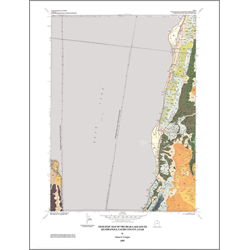
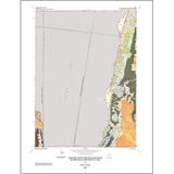
Geologic map of the Bear Lake South quadrangle, Rich County, Utah (MP 97-1)
By: J. C. Coogan
The Bear Lake South and adjacent Sheeppen Creek quadrangles cover part of southern Bear Lake Valley, western Bear Lake Plateau, and the eastern foothills of the Bear River Range in Rich County, Utah. Geologic interest in the area has increased in the past two decades because of oil and gas discoveries in adjacent areas of the Wyoming-Idaho-Utah portion of the Cordilleran thrust belt, earthquake hazards along the eastern Bear Lake fault zone, and recreational development demands along the Bear Lake shoreline.
Cambrian, Triassic, Jurassic, and Eocene sedimentary rocks, and Quaternary sediments are exposed in the Bear Lake South quadrangle, and a complete Triassic to Cambrian sedimentary section is known to underlie the surface exposures from outcrops and wells in adjacent areas. The Paleozoic through Jurassic miogeoclinal strata were shortened in a series of north-trending thrust faults and associated folds as part of the Cretaceous to early Eocene Sevier thrust belt. The lower Eocene Wasatch Formation consists of fluvial clastic rocks and lacustrine limestones that were deposited in a piggyback basin after main-phase folding and thrusting.
Other Information:
Published: 1997
Pages: 16 p.
Plates: 3 pl.
Scale: 1:24,000
Location: Rich County
Media Type: Paper Map