


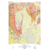
Geologic map of the Sage Valley quadrangle, Juab County, Utah (MP 03-2)
By: D. L. Clark
The Sage Valley quadrangle is in the eastern Basin and Range Province of central Utah, and in an area of overlapping structural elements. Through geologic time, this area was also located along ?Utah?s hingeline,? within the Sevier thrust belt, on the southern margin of the East Tintic Mountains volcanic field, and within an estuary of Lake Bonneville.
The principal geologic resources in the quadrangle are sand and gravel, stone, and aragonite; there are also possibilities for metallic minerals and hydrocarbons. Presently, the agricultural value and water rights are the most used resources, and the area is an important transportation and utility corridor. Geologic hazards that could pose future problems include earthquakes, mass movements, problem soils and rocks, flooding, and radon.
Other Information:
Published: 2002
Pages: 55 p.
Plates: 2 pl.
Scale: 1:24,000
Location: Salt Lake County
Media Type: Paper Map