


Geologic map of the Alton quadrangle, Kane County, Utah (MP 01-4)
MP-014
In stock
1:24,000 Geologic Maps
$9.95
By: T. L. Tilton
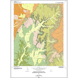
The Alton quadrangle is located in north-central Kane County and covers the southwestern part of the Paunsaugunt Plateau. The approximately 4,000-foot-thick section of exposed sedimentary rock in the quadrangle ranges in age from Jurassic to Oligocene. Quaternary alluvium, mass-movement debris, pediment alluvium, and landslides cover these rocks. An igneous dike of Quaternary basalt is exposed near the center of the Alton quadrangle.
Other Information:
Published: 2001
Pages: 22 p.
Plates: 2 pl.
Scale: 1:24,000
Location: Kane County
Media Type: Paper Map