


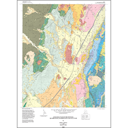

Geologic map of the Pintura quadrangle, Washington County, Utah (M-196)
M196
In stock
1:24,000 Geologic Maps
$11.95
By: H. A. Hurlow and R. F. Biek
This report describes selected aspects of the geology of the Pintura quadrangle. The quadrangle includes Permian through early Tertiary sedimentary rocks, middle Tertiary intrusive and volcanic rocks, and Quaternary volcanic rocks and surficial deposits. Mesozoic to early Cenozoic compressional deformation in the Utah-Idaho-Wyoming section of the Sevier orogenic belt, followed by Cenozoic magmatism and extensional faulting, created complex structural relations within the quadrangle. These structures are the main focus of this report.
Other Information:
Published: 2003
Pages: 20 p.
Plates: 2 pl.
Scale: 1:24,000
Location: Washington County
Media Type: Paper Map