


Geologic maps of the Clarkston and Portage quadrangles, Box Elder and Cache Counties, Utah and Franklin and Oneida Counties, Idaho (M-194)
By: R. F. Biek, R. Q. Oaks, Jr., S. U. Janecke, B. J. Solomon, and L. M. S. Barry
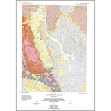
The Clarkston and Portage quadrangles lie astride the boundary between the Basin and Range and Middle Rocky Mountains physiographic provinces. The quadrangles straddle Clarkston Mountain, the southern extension of the Malad Range of southern Idaho, which consists of a complexly faulted sequence of generally east-dipping lower Paleozoic strata. Nearly 8,000 ft of Middle Cambrian to Silurian carbonate and fine-grained clastic strata are exposed on Clarkston Mountain. The oldest rocks were previously assigned to the Ute, Blacksmith, and Bloomington Formations, but are herein reinterpreted, respectively, as the Hodges Shale, middle limestone, and Calls Fort Shale members of the Bloomington Formation. The Bloomington Formation is overlain by the Nounan, St. Charles, Garden City, Swan Peak, Fish Haven, and Laketown Formations. Oquirrh Formation strata are exposed in the West Hills and Junction Hills, and the Garden City Formation at Bergeson Hill. We also mapped the Paleocene-Eocene Wasatch(?) Formation, the Miocene-Pliocene Salt Lake Fonnation, and a variety of unconsolidated sediments, including extensive Pleistocene Lake Bonneville deposits, in the quadrangles.
Other Information:
Published: 2003
Pages: 41 p.
Plates: 3 pl.
Scale: 1:24,000
Location: Box Elder County and Cache County
Media Type: Paper Map