


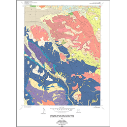
Geologic map of the Center Creek quadrangle, Wasatch County, Utah (M-192)
M192
In stock
1:24,000 Geologic Maps
$11.95
By: R. F. Biek, M. D. Hylland, J. E. Welsh, and M. Lowe
The Center Creek quadrangle lies astride a structural and topographic saddle between the Wasatch Range and Uinta Mountains. The quadrangle includes three distinct groups of rocks: (1) allochthonous, Permian to Pennsylvanian Oquirrh Formation in the Charleston thrust plate that is deformed into two large, southeast-plunging folds; (2) parautochthonous, southwest-dipping Mesozoic strata beneath the Charleston thrust; and (3) subhorizontal, Oligocene to Eocene clastic and volcanic rocks that unconformably overlie older strata.
Other Information:
Published: 2003
Pages: 25 p.
Plates: 2 pl.
Scale: 1:24,000
Location: Wasatch County
Media Type: Paper Map