


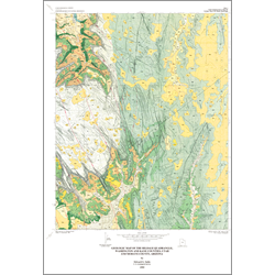
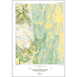
Geologic map of the Hildale quadrangle, Washington and Kane Counties, Utah and Mohave County, Arizona (M-167)
By: E. G. Sable
The Hildale quadrangle, named from the town of Hildale in its southwest comer, straddles the boundary between Washington and Kane Counties, Utah, along the Arizona border. The area is located within the Colorado Plateaus physiographic province, and is mostly characterized by rolling upland surfaces that average roughly 6,500 feet altitude along the divide between the north-flowing Virgin River tributaries and the south-flowing streams of Short Creek and Cottonwood Canyon. Canaan Mountain and South Mountain rise 1,700 to 2,500 feet above the main drainages; they consist of sandstone bedrock and sand. Lowland areas along South and Short Creeks and Cottonwood Canyon consist of steep slopes and ledges mostly covered by rock and soil debris, above which rise the precipitous Vermilion Cliffs. The highest point is 7,175 feet above mean sea level on Canaan Mountain, the lowest is less than 4,200 feet along South Creek.
Other Information:
Published: 1995
Pages: 14 p.
Plates: 2 pl.
Scale: 1:24,000
Location: Kane County and Washington County
Media Type: Paper Map