


Geologic map of the McCornick quadrangle, Millard County, Utah (M-165)
By: F. D. Davis
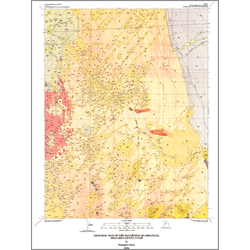
The McCornick quadrangle covers an area marginal to the eastern Sevier Desert and the northern part of Pahvant Valley in eastern Millard County, Utah. Deposits ranging in age from late Miocene to late Holocene are exposed in the quadrangle. The Oak City Formation (upper Miocene and Pliocene) is poorly exposed in two knolls in the east-central part of the map area. A thin, nearshore facies of an upper Pliocene to Pleistocene lacustrine unit is exposed in the northwest part of the quadrangle and Pahvant Ridge basalt of late Pleistocene, pre-Lake Bonneville age is present in the western part of the map area. The remainder of the quadrangle is covered by upper Pleistocene Lake Bonneville deposits and Holocene alluvium, eolian sand and mud, and deflation playas.
Other Information:
Published: 1994
Pages: 13 p.
Plates: 2 pl.
Scale: 1:24,000
Location: Millard County
Media Type: Paper Map