


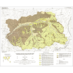
Quaternary geologic map of the Upper Weber River Basin drainage, Summit County, Utah (M-156)
By: C. G. Oviatt
Quaternary deposits in part of the western Uinta Mountains of northeastern Utah have been mapped at a scale of 1:50,000. The map area includes parts of eight 7.5-minute quadrangles. Numerous Quaternary landslides, and glacial deposits of one major Pleistocene glaciation (Pinedale) are widespread in the area. Significant potential geologic hazards from mass-wasting processes include large landslides, slumps, rockslides, debris slides, avalanches, and rock fall, as well as high runoff and sediment production caused by increasing land use on steep slopes.
The map area includes parts of the following USGS 7.5-minute quadrangles: Crandall Canyon, Hidden Lake, Slader Basin, Whitney Reservoir, Kamas, Hoyt Peak, Erickson Basin, and Mirror Lake. Surficial deposits were mapped in the field on aerial photographs at a scale of 1:24,000, and the data were transferred to 1:24,000-scale orthophotoquads, which were then reduced and compiled at a scale of 1:50,000.
Other Information:
Published: 1994
Pages: 10 p.
Plates: 1 pl.
Scale: 1:50,000
Location: Summit County
Media Type: Paper Map