


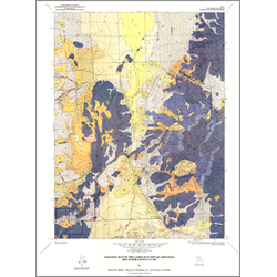

Geologic map of the Lampo Junction quadrangle, Box Elder County, Utah (M-136)
By: D. M. Miller, M. D. Crittenden Jr., and T. E. Jordan
The Lampo Junction quadrangle is located north of the Great Salt Lake in northern Utah and encompasses parts of Blue Creek Valley, Blue Spring Hills, and Engineer Mountain. Bedrock exposed in the Blue Spring Hills and Engineer Mountain are Paleozoic miogeoclinal rocks composed mainly of limestone and dolomite, with minor quartzite and shale. These rocks include the Mississippian and Pennsylvanian Manning Canyon Shale and the Early Pennsylvanian to Early Permian Oquirrh Formation. Overturned folds and thrust faults cutting these rocks are inferred on the basis of regional relations to be of probable Mesozoic age. Cutting the thrusts are normal faults interpreted as related to the Cenozoic faults that created the north-trending block-faulted mountain ranges. The mountain ranges are separated by broad valleys containing Cenozoic deposits. Tertiary sediments at Lampo Junction record a long history of basin development and of volcanism accompanying the extensional tectonism. The youngest Tertiary sediments in the Lampo Junction area are remnants of loess sheets and extensive alluvial piedmonts. These sediments show only minor effects ofextensional tectonics. Alluvial fans and piedmonts along the margins of Blue Creek Valley and alluvial plains in the floor of the valley are Pleistocene and Holocene in age. Pleistocene Lake Bonneville covered Blue Creek Valley and parts of adjacent hills, blanketing much of the lowland with sediments, and leaving behind many shoreline features.
Our geologic mapping began as part of a tectonic synthesis of the region from the thrust belt in the Wasatch Range westward to the belt of metamorphic terranes near the western border of Utah. The Blue Spring Hills and associated smaller hills previously had been mapped only in reconnaissance. Recently, detailed geologic maps of adjoining quadrangles and parts of the nearby North Promontory Mountains have been published, and a detailed reconnaissance map by Crittenden depicts the geology of the Promontory Mountains. Allmendinger and others summarized the stratigraphic, geometric, and age relations of thrust faults in the vicinity of the Lampo Junction quadrangle.
Other Information:
Published: 1991
Pages: 17 p.
Plates: 2 pl.
Scale: 1:24,000
Location: Box Elder County
Media Type: Paper Map