


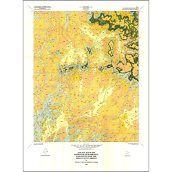
Geologic map of the Elephant Butte quadrangle, Kane County, Utah and Mohave County, Arizona (M-126)
M126
In stock
1:24,000 Geologic Maps
$7.95
By: E. G. Sable and H. H. Doelling
Field mapping supplemented by aerial photograph interpretation has delineated exposures of three bedrock formations of Jurassic age and eight informal surficial units of Quaternary age in the scenic Elephant Butte quadrangle. Structure is relatively simple and consists of a gentle northeast-dipping homo cline broken by high-angle extensional faults with small displacements and joints with dominant north-northeast and north-northwest trends.
Other Information:
Published: 1990
Pages: 10 p.
Plates: 2 pl.
Scale: 1:24,000
Location: Kane County
Media Type: Paper Map