


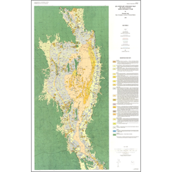
Quaternary geologic map of Tule Valley, west-central Utah (M-124)
By: D. Sack
Tule Valley contained an independent paleolake before and after its isotope stage 2 integration with Lake Bonneville. Tule Valley probably also experienced a period of Bonneville basin integration during the Little Valley lake cycle of isotope 6. In interlacustral intervals, alluvial-fan, playa, and eolian processes dominated Tule Valley’s depositional system. The study area currently displays a wide variety of Quaternary sediments, including material deposited in alluvial, eolian, lacustrine, mass-wasting, playa, an d spring environments. The Quaternary geologic map portrays sediments deposited within several subenvironments of these categories. Alluvial and lacustrine sediments are the most common deposits.
The purpose of this study was to 1.) map the Quaternary deposits, major shorelines, and piedment fault scarps of Tule Valley, and 2.) interpret the late Quaternary history of Tule Valley.
Other Information:
Published: 1990
Pages: 26 p.
Plates: 1 pl.
Scale: 1:100,000
Location: Juab County and Millard County
Media Type: Paper Map