


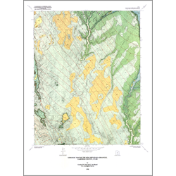
Geologic map of the King Bench quadrangle, Garfield County, Utah (M-119)
M119
In stock
1:24,000 Geologic Maps
$7.95
By: G. W. Weir and L. S. Beard
The King Bench quadrangle in central Garfield County, south-central Utah, lies in the Circle Cliffs-Teasdale section of the Colorado Plateau physiographic province. Mesas, flat-topped ridges, and uneven benches bordered by steep cliffs that descend to deep, narrow canyons form the landscape. Total relief in the quadrangle is more than 1800 feet; local relief is commonly several hundreds of feet.
Other Information:
Published: 1990
Pages: 5 p.
Plates: 2 pl.
Scale: 1:24,000
Location: Garfield County
Media Type: Paper Map