


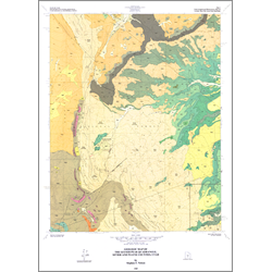

Geologic map of the Geyser Peak quadrangle, Wayne and Sevier Counties, Utah (M-114)
By: S. T. Nelson
The Geyser Peak 7.5-minute quadrangle encompasses the extreme eastern part of the Marysvale-Pioche volcanic belt in the Fish Lake Plateau of south-central Utah. The plateau is capped by Tertiary lava flows which have received little geologic investigation. These flows are underlain by a thick sequence of Mesozoic sedimentary rocks. Jurassic, Cretaceous and Tertiary sedimentary rocks, including beds of coal, are exposed in the eastern part of the quadrangle. They include, from the base upwards: 1) Carmel Formation, 2) Entrada Sandstone, 3) Curtis Formation, 4) Summerville Formation, 5) Morrison Formation, 6) Cedar Mountain Formation, 7) Dakota Sandstone, 8) Tununk Shale, Ferron Sandstone, and Blue Gate Shale Members of the Mancos Shale, 9) Black Hawk Formation, and 10) Flagstaff Limestone. Large Quaternary landslides have sloughed off the north-south-trending eastern escarpment of the plateau and have involved both the Mesozoic and Tertiary sections.
Other Information:
Published: 1989
Pages: 18 p.
Plates: 2 pl.
Scale: 1:24,000
Location: Sevier County and Wayne County
Media Type: Paper Map