


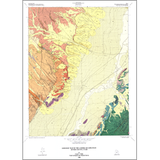
Geologic map of the Aurora quadrangle, Sevier County, Utah (M-112)
By: G. C. Willis
The Aurora quadrangle is located in the central Sevier Valley of Utah near Richfield. It contains more than 6000 feet of Jurassic rocks and as much as 7000 feet of exposed Tertiary and Quaternary rocks. No Cretaceous rocks are exposed due to a major angular unconformity. Rocks in the quadrangle can be divided into five groups: 1) marine, restricted marine, and marginal marine deposits that are , Jurassic-Callovian in age, 2) Paleocene and Eocene fluvial-lacustrine rocks, 3) Oligocene and Miocene volcanic and volcaniclastic rocks, 4) Miocene to Holocene alluvial and lacustrine rocks with minor volcanic material, and 5) surficial deposits which range up to a few hundred feet thick.
Other Information:
Published: 1988
Pages: 21 p.
Plates: 2 pl.
Scale: 1:24,000
Location: Sevier County
Media Type: Paper Map