


Geologic map of the Lemay Island quadrangle, Box Elder County, Utah (M-96)
By: D. M. Miller and L. L. Glick
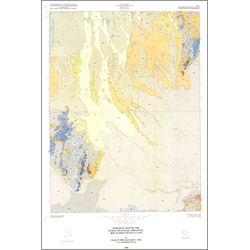
The Lemay Island quadrangle in northwest Utah comprises lowland of the Great Salt Lake Desert, the northern end of the Silver Island Mountains (known as Crater Island), and part of the Little Pigeon Mountains and Lemay Island. In this part of Utah, island is commonly applied to a mountainous feature that rises from mud flats or other flatland of the desert. Lemay Island, at an elevation of 4,906 feet, is the highest point in the quadrangle; the lowest point is slightly under 4,240 feet near Crater Island. The flatland in the quadrangle is divided into two realms- (1) anastomosing stream deposits, eolian sands, and alluvial fan deposits that slope gently southward to the Grouse Creek sinks, where ephemeral streams derived from Grouse Creek stop; and (2) white mud flats or playa deposits along the south margin of the quadrangle, most of which are part of the Pilot Valley playa described by Lines.
Other Information:
Published: 1986
Pages: 9 p.
Plates: 2 pl.
Scale: 1:24,000
Location: Box Elder County
Media Type: Paper Map