


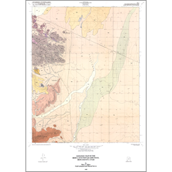
Geologic map of Beryl Junction quadrangle, Iron County, Utah (M-85)
By: M. A. Siders
Mapping of the Beryl Junction quadrangle reveals that the area includes volcanic rocks of Oligocene through Miocene age, as well as a thick volcaniclastic sequence and a variety of Quaternary deposits. Previously unmapped and undescribed volcanic units have been studied and defined in order to provide a geologic base map upon which future studies can expand. Field mapping was assisted by the use of aerial photographs, and descriptions of the volcanic rocks include petrographic and geochemical data as well as observational data from the field. Epithermal veins within the volcaniclastic sequence (mine series) contain silver mineralization that is exploited by the Escalante silver mine. The main silver vein breaks into several smaller veins at its southern end. The northeasterly trend of the vein is truncated by a normal fault trending N 30? W, and a complementary portion of the vein may be shallowly buried under alluvium. A more major north-trending normal fault probably truncates this complementary portion of the vein, which may continue at depth under the alluvium of the Escalante Desert. Although the quadrangle is extensively staked and numerous prospect pits have been dug in other parts of the quadrangle, the silver mineralization is only known to occur within the Escalante vein and its offshoots.
Other Information:
Published: 1985
Pages: 11 p.
Plates: 2 pl.
Scale: 1:24,000
Location: Iron County
Media Type: Paper Map