


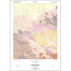
Geologic map of Pinon Point quadrangle, Iron county, Utah (M-84)
By: M. A. Siders
Mapping of the Pinon Point quadrangle reveals that the area is dominated by volcanic rocks of Oligocene through Miocene age. Previously unmapped and undescribed volcanic units have been studied and defined in order to provide a geologic base map upon which future studies can expand. Field mapping was supplemented by aerial photography, and descriptions of the volcanic rocks include petrographic and geochemical data, as well as observational data from the field. Results of the study define the occurrence of both calc-alkaline and bimodal magmatism within the quadrangle. A thick sequence of volcaniclastic rocks, which host silver mineralization in the adjacent Beryl Junction quadrangle, are poorly exposed and bounded by faults in the east-central portion of the Pinon Point quadrangle. The surficial geology within the quadrangle lacks evidence of extensive hydrothermal alteration and no geochemical anomalies have yet been documented. Although data are scarce, at the present time no geothermal prospects or anomalies are known to occur in the quadrangle.
Other Information:
Published: 1985
Pages: 12 p.
Plates: 2 pl.
Scale: 1:24,000
Location: Iron County
Media Type: Paper Map