


Surface-water resources of the northern Wasatch Front, Utah (M-53B)
By: D. Price and L. J. Jensen
The northern Wasatch Front map covers parts of two major physiographic provinces. The Middle Rocky Mountains province extends eastward from the western base of the Wasatch Mountains. It consists of high rugged mountains among which are nestled three prominent valleys ? Cache, Ogden, and the Weber River. The other major physiographic province is the Basin and Range that extends westward from the base of the Wasatch Mountains. This province is character by relatively narrow north-south trending mountain ranges that are separated by broad sediment-filled valleys.
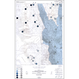
The purpose of this map is to show in a general way the amount and dissolved solids concentration of surface-water in the northern part of the Wasatch Front and to guide readers to sources of more detailed information about runoff characteristics and quality of surface-water in the area.
Other Information:
Published: 1983
Plates: 2 pl.
Scale:1:100,000
Location: Box Elder County, Cache County, Davis County, Morgan County, and Weber County
Media Type: Paper Publication