


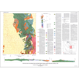
Geologic map of the Indian Peak (Southern Needle) Range, Beaver and Iron Counties, Utah (I-1795)
I1795
In stock
1:62,500 and 1:50,000 Geologic Maps
$7.95
By: M. G. Best, S.K. Grant, L.F. Hintze, J.G. Cleary, A. Hutsinpiller, and D.M. Saunders
Geologic maps use a combination of colors, lines, and symbols to depict the relative age, composition, and relationships among rocks and sediments at and near the earth's surface.
Other Information:
Published: 1987
Plates: 1 pl.
Scale: 1:50,000
Color/B&W: B&W
Location: Beaver County and Iron County