


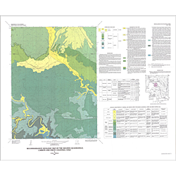
Reconnaissance geologic map of the Mounds quadrangle, Carbon and Emery Counties, Utah (I-1202)
I1202
In stock
1:24,000 Geologic Maps
$7.95
By: I. J. Witkind
Geologic maps use a combination of colors, lines, and symbols to depict the relative age, composition, and relationships among rocks and sediments at and near the earth's surface.
Other Information:
Published: 1980
Plates: 1 pl.
Scale: 1:24,000
Color/B&W: Color
Location: Carbon County and Emery County