


Sold Out

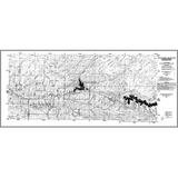
Argyle Canyon-Willow Creek tar sand deposit isopach map (Duchesne County) (OFR-100)
OFR100
Unstocked
Utah Geological Survey Open File Report
$3.00
By: B. T. Tripp
This tar sand deposit isopach map shows the location of the tar sand beds, tar sand thickness measurement locations, tar sand isopach lines, and special tar sand area boundaries.
Other Information:
Published: 1986
Plates: 1 pl.
Scale: 1:50,000
Location: Duchesne County
Media Type: Paper Map